


FISHBUOY TripPlanner is the ultimate tool for planning your next fishing trip. From maps to weather to your own history of fish catch data. Plan right, fish smart, catch fish.

FISHING MAPS
Fishermen, like many other outdoor enthusiasts, rely heavily on maps. Maps offer a means of getting from point A to point B, in addition provide topography, water course information and natural characteristcs that provide additional insight into picking the right locations to fish. Now, imagine integrating map information with temporal fish-relevant data including historical and real-time water, weather and fish catch data.
FISHBUOY is like a living map, providing up-to-date information about key factors that influence fishing success. FISHBUOY maps evolve with time, providing the latest information about publicly or privately posted fish catches.
|
HIGHLIGHTS |
WHY UNDERSTANDING MAPS WILL HELP YOU CATCH FISH |
|---|---|
|
Spatial Trends |
Visual display of fish catch clusters on a map can show fishing hotspots or common places to fish. |
|
Temporal Trends |
Once you identify high density clusters of fish catch photos, your next step is to look at time related information to determine when and under what conditions fish were caught. |
|
Multi-Source Data Integration |
FISHBUOY offers one platform for viewing real-time water data, weather data, fish catch data, map data and time-related data to help you plan smarter. |
|
Real-Time Data |
Once you have identified potential places to fish, then it's time to look at water conditions. Pick from thousands of water bodies that are monitored daily for water levels, water discharge, water turbidity or water temperatures and align your trips to the right conditions. |
|
Fishing Success Index (FSI) |
Understanding fish biology and predicting how water and weather conditions influence fish activity can be tricky. That's why we invented the Fishing Success Index (FSI). FSI uses a proprietary algorithm to calculate locations meeting the ideal physical and biological conditions that impact your fishing success. This is no voo doo magic or farmers almanc guessing. FSI uses spatial and temporal modeling techniques to produce a probability of success and displays results on a map. |
* - Data dependent on monitoring station data availability and varies from state to state, province to province. Talk with your local water agencies to expand the network!

WATER LEVELS
Water levels play an important role when determining the best places to fish. Whether fishing man-made reservoirs or natural rivers, both fluctuate throughout the year based on precipitation amounts or operational works. Changes in water levels directly influence fish feeding behaviour and holding patterns. If you want to catch fish, you will need to begin developing your knowledgebase.
FISHBUOY helps by providing water level data for major reservoirs, lakes, rivers and streams across North America. FISHBUOY TripPlanner integrates with the USGS National Water Information System and the Water Office of Canada to provide real-time and historical water data that you can use to make smarter decisions.
|
HIGHLIGHTS |
WHY UNDERSTANDING WATER LEVELS WILL HELP YOU CATCH FISH |
|---|---|
|
"Ups" and "Downs" |
There is no better time to fish when water is on the 'rise' or the 'decline'. FISHBUOY offers the ability to create custom alerts based on water levels. |
|
Changing Fishing Structure |
During high reservior levels, fish may find more structure along the shorelines. As water recedes, those structures move above the waterline, forcing fish to find new structure. Use FISHBUOY photos to establish those locations. |
|
Water Clarity |
In the absence of turbidity monitoring, water levels can offer hints to what the water clarity may look like. Pay attention to your fish photo data and begin to build your history, correlating water levels with fish catches. |
|
Safety on the Water |
High water can create dangerous wading conditions, low water can create hazardous boating conditions. Pay attention! |
* - Data dependent on monitoring station data availability and varies from state to state, province to province. Talk with your local water agencies to expand the network!

WATER DISCHARGE
Why do fishermen care about water discharge? How can fishermen benefit from having this data? Water discharge, or streamflow, is a terrific indicator of how fast or slow water is moving in a river, stream or reservoir. This helps fishermen determine whether a location is fishable to begin with. Understanding discharge can also help fishermen determine the right tactics for high or low discharge rates. Use FISHBUOY Photos to create a history of discharge rates vs. fish catches to determine your optimal flows.
|
HIGHLIGHTS |
WHY UNDERSTANDING DISCHARGE WILL HELP YOU CATCH FISH |
|---|---|
|
Water Preference |
Fish will favour their biological preferences to water flow. During high discharge, look for seams and slower moving pockets of water. |
|
Feeding Behaviour |
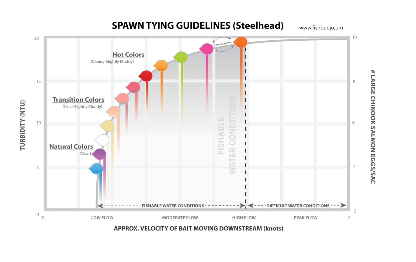
High discharge rates impacts the amount of time your bait is in a fishes visual strike zone. Make it easier for fish to see your bait by using larger baits or higher vis colors. (See Great Lakes Spawn Tying Guidelines) |
|
Seasonal Trigger |
Pay attention to signifcant increases in discharge rates around the time of spawning periods. High stream flows flush sweet water into large water bodies and can act as a trigger for pre-spawn migrations. |
* - Data dependent on monitoring station data availability and varies from state to state, province to province. Talk with your local water agencies to expand the network!

WATER TURBIDITY
FISHBUOY TripPlanner provides real-time and historical water turbidity graphs for rivers and reservoirs across North America. In a single view, you will better understand which water is fishable, and which is blown. You will also have the ability to correlate historical weather events and how they impact water turbidty. This allows fishermen to predict what water conditions might look like in a few days based on the precipitation forecast.
|
HIGHLIGHTS |
WHY UNDERSTANDING TURBIDITY WILL HELP YOU CATCH FISH |
|---|---|
|
Bait Selection |
Determine the best bait colors and styles for the turbidity levels. |
|
Predict Precipitation Impacts |
Refer to fish catch data and turbidity graphs and anticipate how precipitation with change water turbidity at your favourite fishing spots. |
|
Species Tolerance |
Quick access to fish catch data and turbidity data provides you with deeper insight into which fish are more active during turbidity events. |
* - Data dependent on monitoring station data availability and varies from state to state, province to province. Talk with your local water agencies to expand the network!

WATER TEMPERATURE
Water temperature is among the most important water parameters for fishermen, yet many of us don't take the time to measure conditions in the field. Fly fishermen use water temperature to gauge insect hatches. Great Lakes fishermen use deep water instruments like the FISHHAWK to determine the thermocline where fish are active. Salmon and Steelheaders use water temperature to estimate when fish will start running rivers. Bass fishermen will know when it is time to change to slow presentations or live bait.
Along with other water parameters, FISHBUOY TripPlanner collects water temperatures every hour and stores it for your use. Using the FISHBUOY Mobile Timeline Filter, coupled with FISHBUOY TripPlanner, you will develop a more complete picture of the conditions you are planning for.
|
HIGHLIGHTS |
WHY UNDERSTANDING TEMPERATURE WILL HELP YOU CATCH FISH |
|---|---|
|
Fish Migrations |
Discover water temperatures that trigger pre-and-post spawn movement. Plan to fish then. |
|
Fish Activity |
Determine the range of water temperatures that impact your target fish species. Search the map and determine patterns and trends. |
|
Fish Holding Patterns |
Fish will naturally move to their preferential water temperatures. Start to build a range of water temperatures for your target species by capturing this information using FISHBUOY Mobile. |
|
Fish Presence |
Be smart about how you plan your trips. Don't expect to find Brook Trout in warm water reservoirs. Pay attention to water temperature. |
* - Data dependent on monitoring station data availability and varies from state to state, province to province. Talk with your local water agencies to expand the network!


Learn how levels affect fishing.

Know what flow rate is best.

Fish when water clarity is right.
FISHBUOY helps fishermen by providing water data for major reservoirs, lakes, rivers and streams across North America. FISHBUOY integrates data from the USGS National Water Information System and the Water Office of Canada to provide real-time and historical water data that you can use to make smarter decisions. Get FISHBUOY today and start learning how water conditions impact your fishing success.
Water levels play an important role when determining the best places to fish. Whether fishing man-made reservoirs or natural rivers, both fluctuate throughout the year based on precipitation amounts or operational works. Changes in water levels directly influence fish feeding behaviour and holding patterns. If you want to catch fish, you will need to begin developing your knowledgebase.
HIGHLIGHTS | WHY UNDERSTANDING WATER LEVELS WILL HELP YOU CATCH FISH |
|---|---|
"Ups" and "Downs" | There is no better time to fish when water is on the 'rise' or the 'decline'. During rise periods, migrating fish use the higher levels to move through shallow areas. It also provides a higher concentration of food sources that can trigger feeding. Anglers can take advantage of rise periods by focusing on more noticable current breaks for example behind rocks, in high/low velocity seams, etc. Declining water levels often put fish into a holding pattern, patiently waiting for the next rise in water level to move up river. Low water level periods help to concentrate fish in pools and deeper water riffle areas and can offer anglers amazing fishing opportunities. |
Changing Fishing Structure | During high reservior levels, fish may find more structure along the shorelines. As water recedes, those structures move above the waterline, forcing fish to find new structure. Use FISHBUOY photos to establish those locations. |
Water Clarity | In the absence of turbidity monitoring, water levels can offer hints to what the water clarity may look like. Pay attention to your fish photo data and begin to build your history, correlating water levels with fish catches. |
Safety on the Water | High water can create dangerous wading conditions, low water can create hazardous boating conditions. Pay attention! |
Why do fishermen care about water discharge? How can fishermen benefit from having this data? Water discharge or streamflow are terrific indicators of how fast or slow water is moving in a river, stream or reservoir. This helps fishermen determine whether a location is fishable to begin with. Understanding discharge can also help fishermen determine the right tactics for high or low discharge rates. Use FISHBUOY Photos to create a history of discharge rates vs. fish catches to determine your optimal flows.
HIGHLIGHTS | WHY UNDERSTANDING DISCHARGE WILL HELP YOU CATCH FISH |
|---|---|
Water Preference | Fish will favour their biological preferences to water flow. During high discharge, look for seams and slower moving pockets of water. |
Feeding Behaviour | High discharge rates impacts the amount of time your bait is in a fishes visual strike zone. Make it easier for fish to see your bait by using larger baits or higher vis colors. (See Great Lakes Spawn Tying Guidelines) |
Seasonal Trigger | Pay attention to signifcant increases in discharge rates around the time of spawning periods. High stream flows flush sweet water into large water bodies and can act as a trigger for pre-spawn migrations. |
FISHBUOY TripPlanner provides real-time and historical water turbidity graphs for rivers and reservoirs across North America. In a single view, you will better understand which water is fishable - and which is blown. You will also have the ability to correlate historical weather events and how they impact water turbidty. This allows fishermen to predict what water conditions might look like in a few days based on the precipitation forecast.
HIGHLIGHTS | WHY UNDERSTANDING TURBIDITY WILL HELP YOU CATCH FISH |
|---|---|
Bait Selection | Determine the best bait colors and styles for the turbidity levels. |
Predict Precipitation Impacts | Refer to fish catch data and turbidity graphs and anticipate how precipitation with change water turbidity at your favourite fishing spots. |
Species Tolerance | Quick access to fish catch data and turbidity data provides you with deeper insight into which fish are more active during turbidity events. |
Water temperature is among the most important water parameters for fishermen, yet many of us don't take the time to measure conditions in the field. Fly fishermen use water temperature to gauge insect hatches. Great Lakes fishermen use deep water instruments like the FISHHAWK to determine the thermocline where fish are active. Salmon and Steelheaders use water temperature to estimate when fish will start running rivers. Bass fishermen will know when it is time to change to slow presentations or live bait. Along with other water parameters, FISHBUOY TripPlanner collects water temperatures every hour and stores it for your use. Using the FISHBUOY Mobile Timeline Filter, coupled with FISHBUOY TripPlanner, you will develop a more complete picture of the conditions you are planning for.
HIGHLIGHTS | WHY UNDERSTANDING TEMPERATURE WILL HELP YOU CATCH FISH |
|---|---|
Fish Migrations | Discover water temperatures that trigger pre-and-post spawn movement. Plan to fish then. |
Fish Activity | Determine the range of water temperatures that impact your target fish species. Search the map and determine patterns and trends. |
Fish Holding Patterns | Fish will naturally move to their preferential water temperatures. Start to build a range of water temperatures for your target species by capturing this information using FISHBUOY Mobile. |
Fish Presence | Be smart about how you plan your trips. Don't expect to find Brook Trout in warm water reservoirs. Pay attention to water temperature. |


Adjust trolling speeds to lure action.

Find the right water temps.

Be safe on the water.
Understanding marine weather before heading out is critical to catching more fish and being safe. FISHBUOY has incorporated marine forecasts to help fishermen determine where to launch, where to run to, and if it just makes sense to just stay home. The combination of mapping your historical fish catches and overlaying marine data will give you a true big picture view. Get FISHBUOY today and start learning how marine conditions impact your fishing.
|
HIGHLIGHTS |
WHY UNDERSTANDING MARINE WEATHER WILL HELP YOU CATCH FISH |
|---|---|
|
Wave Heights |
No matter how big your boat, wave heights are a key safety consideration. Please pay attention before you head out. When wave heights do not pose a safety concern, they still impact your level of comfort and the impact your boat haul takes on the run out - and the run back to the dock. FISHBUOY's marine weather map layer helps fishermen determine their ideal angle of departure from the dock, trolling direction, initial setup locations, trolling techniques, lure choice etc. |
|
Surface Water Temperatures |
Chart captains on the Great Lakes have learned that following warm surface water movements leads to more hook-ups with monster Walleye. On the other hand, when targetting Steelhead and Rainbow Trout, cold water regimes can produce more fish. Travelling 5-12 miles out can be a costly expense so planning ahead and finding pockets of warm or cold water before heading out will help you catch more fish and save you on gas money. Pay attention to surface water temperatures. |
|
Lake Currents |
Great Lakes water currents change from day-to-day and hour-to-hour. Currents have a direct influence on migrating bait fish, presence of predatory fish, lure action, and shoreline turbidity. Determining which boat launch to head out from can mean miles of driving. Once in the water, determining the optimal trolling pattern can burn hours until your lures and trolling speed are tuned in. To help fishermen better understand lake currents, FISHBUOY has connected with NOAA to provide you with forecasted water currents data. |
|
Cloud Cover |
Marine wind barbs have been used by sailor and fishermen as a key tool when planning fishing trips on the Great Lakes. Wind bars help to display the wind direction and wind speed, that directly affect wave directions. As part of the MARINEBUOY feature, fishermen can learn the best location to start out from. |
| Fishing Success Index (FSI) | Understanding fish biology and predicting how water and weather conditions influence fish activity can be tricky. That's why we invented the Fishing Success Index (FSI). FSI uses a proprietary algorithm to calculate locations meeting the ideal physical and biological conditions that impact your fishing success. This is no voo doo magic or farmers almanc guessing. FSI uses spatial and temporal modeling techniques to produce a probability of success and displays results on a map. |


See what is coming your way.

Plan better with wind conditions.

Setup the right bait colors.
Weather has a tremendous impact on fishing. Whether you are a weekend warrior or hardcore angler, understanding the conditions you are heading into is key to a successful and safe fishing trip. Fishermen pay attention to weather for a variety of reasons. Changes in wind direction may move bait fish to different areas of the lake, sudden drops in ambient air temperature may create a lock-jaw effect on certain species of fish, cloud cover could spur on the bite. Every successful fishermen has their key weather indicators and the WEATHERBUOY feature is sure to help. Get FISHBUOY today and start learning how weather impacts your fishing.
|
HIGHLIGHTS |
WHY UNDERSTANDING WEATHER WILL HELP YOU CATCH FISH |
|---|---|
|
Doppler Radar |
Animated doppler radar is a practical and sensible map layer we've added to FISHBUOY that depicts oncoming or dissipating weather systems. Use doppler to identify where to fish, and where not to fish considering safety. |
|
Wind Direction |
Wind direction and magnitude is among the most important weather condition an angler will consider. FISHBUOY now incorporates a surface wind map layer to help you make informed decisions about wind that impacts wave height, casting ability, surface light penetration, lake currents and water levels. |
|
Ambient Air Temperature |
Everyone needs to know what kinds of temperatures to expect when heading out for just a few hours, a day or week. FISHBUOY has embedded an air temperature map layer to help you plan your outdoor clothing needs in addition to anticipate how temperatures may impact fishing conditions. |
|
Cloud Cover |
Fish do not have eyelids and as such, use underwater cover to hide from the sun. On overcast days, fish become more active and typically are more easily drawn from cover in less turb water. Use FISHBUOY's weather features to plan how cloud cover will affect the baits you use. |
| Fishing Success Index (FSI) | Understanding fish biology and predicting how water and weather conditions influence fish activity can be tricky. That's why we invented the Fishing Success Index (FSI). FSI uses a proprietary algorithm to calculate locations meeting the ideal physical and biological conditions that impact your fishing success. This is no voo doo magic or farmers almanc guessing. FSI uses spatial and temporal modeling techniques to produce a probability of success and displays results on a map. |


Search new places to catch fish.

Find your past fish catches.

Review fish-catch details.
Fishermen, like many other outdoor enthusiasts, rely heavily on maps. Maps offer a means of getting from point A to point B, in addition provide topography, water course information and natural characteristcs that provide additional insight into picking the right locations to fish. FISHBUOY helps you identify hundreds of thousands of fishing spots from across North America that have been collected and recorded by official fisheries management agencies. Fishing spots are supplemented with your fish catch locations offering you a compact and powerful mapping environment to help you find places to fish. Get it today and find your honey hole.
|
HIGHLIGHTS |
WHY UNDERSTANDING MAPS WILL HELP YOU CATCH FISH |
|---|---|
| Spatial Trends | Visual display of fish catch clusters on a map can show fishing hotspots or common places to fish. |
| Temporal Trends | Once you identify high density clusters of fish catch photos, your next step is to look at time related information to determine when and under what conditions fish were caught. |
| Multi-Source Data Integration | FISHBUOY offers one platform for viewing real-time water data, weather data, fish catch data, map data and time-related data to help you plan smarter. |
| Real-Time Data | Once you have identified potential places to fish, then it's time to look at water conditions. Pick from thousands of water bodies that are monitored daily for water levels, water discharge, water turbidity or water temperatures and align your trips to the right conditions. |
| Fishing Success Index (FSI) | Understanding fish biology and predicting how water and weather conditions influence fish activity can be tricky. That's why we invented the Fishing Success Index (FSI). FSI uses a proprietary algorithm to calculate locations meeting the ideal physical and biological conditions that impact your fishing success. This is no voo doo magic or farmers almanc guessing. FSI uses spatial and temporal modeling techniques to produce a probability of success and displays results on a map. |
|
QUESTIONS? Feel free to drop us a line - click here. One of our representatives will get back to you as soon as possible. |
|---|
