ACCESS LOCAL WEATHER REPORTS | |
|---|---|
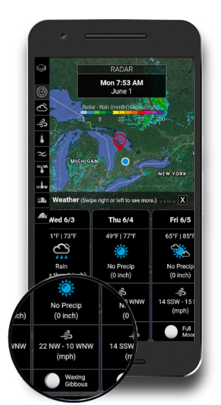
Quick and localized weather data | Find the Weather Chart in the Conditions Tab from the main menu. Simply tap-and-hold on any location across North America to launch local weather data and moon phase. |
High/Low Temperature | Understanding temperatures can mean the difference between bundling up or striping down. It also directly impacts fish sensitive to changes in water temperatures and associated atmospheric pressure changes. |
Cloud Cover/Precipitation Type | Cloud cover percentage and precipitation type provides angles with a good indicator about the conditions they will face while out on the water. Cloudy days may require different lure colors, heavy rain days may require postponing a trip. |
Precipitation Amount | Most serious anglers will always pack a good quality rainsuit however, precipitation can do more than get you wet. Precipitation directly affects river or reservoir conditions. In heavy rains, anglers can expect to see a direct response, with increased water levels, higher turbidity and higher velocity flows. Understanding past and forecasted rains can help anglers plan their trips better. Hint: Often a rise in water levels can mean more food flowing through the system, creating a high feeding time for fish. |
Wind Direction/Magnitude | Wind direction and magnitude can help anglers determine to go fish, or stay home. But lets face it, if there is a bit of wind, most anglers will still head out. In these cases, wind direction helps anglers select where to fish on a lake. For example, during strong north winds, the south shore of a lake can stir up bait, attracting target species. This helps anglers decide to launch on the north or south shore of a big lake. |
Moon Phase | Moon phases can be amazing indicators to determine fish species activity. Whether impacting fish feeding behaviour, fish migrations or spawning periods, moon phase can give anglers the edge. The Weather Chart provide a quick view of past, current and forecasted moon phases so you can plan your trips accordingly. HINT: Musky anglers love full moon fishing. |
FIND KEY LAKE CONTOURS AND SUBSURFACE STRUCTURES | |
|---|---|
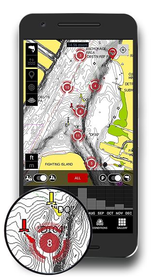
Fishing Lakes and Reservoirs | When fishing out of a boat, it is important to understand key areas that fish like to hang out in. Some fish species prefer deep water, others shallow, and most species relate to humps when feeding. Determining what the lake contours look like will help you find fish. While many anglers have Fishfinders/GPS's onboard, they are unlikely to take them off their boats. This makes the integration of Navionics with FISHBUOY ideal. From the palm of your hands, you can more effectively plan your trips anywhere, anytime. |
Ice Fishing | Most anglers that ice fish walk onto the ice with a general reference of where they want to fish. With Navionics and FISHBUOY, ice anglers can now locate structures and literally navigate to their spots, by following the red arrow as they walk out. Not only that, but when you take a photo of a fish, you will record the location, time and conditions so next year you can get back to your spots. This is hugely powerful! |
Navionics Standard and Sonar Modes | When we integrated Navionics, we wanted to ensure the most popular elements of the app were available through the FISHBUOY interface. For high-resolution contour maps, we have added the famous Navionics Sonar option. This gives a high-density level of lake contours and provides you with more accuracy when setting up. For lakes less travelled, we have also included the standard Navionics maps. Find structure, find fish. |
Compare Catches to Contours | One of the most unique features of Navionics and FISHBUOY is the ability for anglers to record their fish catches and see how they related to lake contours. Every photo you take provides you with more data that allows you to formulate patterns in your catch data. For example, on Lake X, you may find that fish are being caught at certain depth contours, at certain times of the day, under certain water and weather conditions. This is the value of combining a leading lake contour app like Navionics, with an innovative fishing app like FISHBUOY. |
How to get Navionics with FISHBUOY? | FISHBUOY integrates Navionics through an innovative application interface. This means that while we have integrated Navionics into various areas of FISHBUOY, users must still obtain or possess a valid license of the Navionics Boating app. Once you purchase the app, you can simply use the same login credentials to launch Navionics within FISHBUOY. Go to Home/Preferences (top left menu)/Navionics Account and enter your username and password. Navionics in integrated in the MAPS/DATA menu as well as when looking at individual and group photos. |
|
GETTING THE RIGHT SHOT OF YOUR FISH | |
|---|---|
|
Pre-Photo Location |
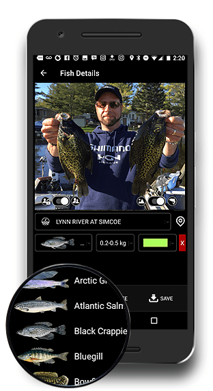
Before you take your photo, the preview panel helps to ensure your mobile device GPS has recognized your current location and provides a visual cue of your geographic location. |
|
Private Photo Lock |
FISHBUOY Mobile provides you with the ability to keep all your fish records private. You do not need to share photos to see the value of FISHBUOY. By default, the "private" photo option is selected. |
|
Public Photo Share |
When taking a photo, you have the option to share it with the FISHBUOY community by swiping to the "public" option. You may at anytime in the future change this to private. |
|
Fishing Condition Capture |
Want to simply take a photo as a visual cue of general environmental conditions? Have the leaves turned color and fallen off the trees? Is the water murky or clear? Are spawn beds present? Have lily pads or weed beds formed? All these non-fish photos act as great clues for timing your next trip. Simply swipe from 'Fish' to 'Environment' when taking your photo. |
|
KNOW YOUR WATER. CATCH MORE FISH. | |
|---|---|
|
Water Levels |
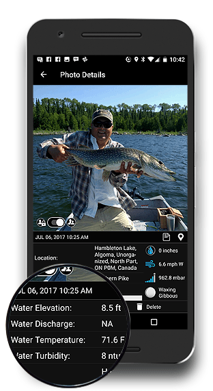
Understanding water levels helps fishermen to determine where and when too fish. High water levels may mean unfishable conditions. Low water levels may require you to go to deeper areas. Until you start capturing this information when you fish, you will never know. |
|
Water Discharge (Streamflow) |
Water discharge or "streamflow" is an excellent measurement for fishermen to gauge the velocity of water moving in a reservoir, river or stream. Fly fishermen and steelheaders fishing rivers and streams, and bass fanatics fishing reservoirs have learned that changes in flow directly influence where fish hold and feed. Pay attention, capture data and hone in on places matching current conditions. |
|
Water Temperature* |
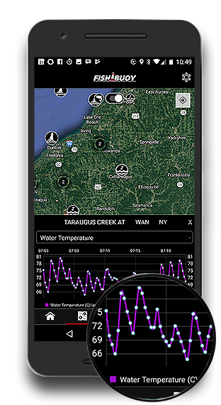
Water temperatures can literally make or break your fishing trip. All fish species have their preferred water temperatures for feeding, spawning and resting. Rapid changes in water temperature can completely shut down fish activity, or spur on a feeding frenzy! Use FISHBUOY to capture temperature data so you can plan your next trip for success.* |
|
Water Turbidity* |
Water clarity is an important factor when fishing. Most freshwater fish are visual feeders and require clear water to identify and select their bait. Fishing clear water requires a completely different setup and color selection compared to fishing murky waters that require noisy, scented baits. FISHBUOY Mobile helps you determine a historical pattern related to water turbidity, location and bait color selection. |
|
PHOTOS/WATER DATA |
WHY UNDERSTANDING WATER LEVELS WILL HELP YOU CATCH FISH |
|---|---|
|
Tagged Water Levels |
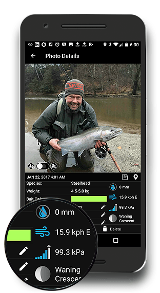
Water levels play an important role when determining the best places to fish. Whether fishing man-made reservoirs or natural rivers, both fluctuate throughout the year based on precipitation amounts or operational works. Changes in water levels directly influence fish feeding behaviour and holding patterns. If you want to catch fish, you will need to begin developing your knowledgebase. Learn more. |
|
Tagged Water Discharge |
Why do fishermen care about water discharge? How can fishermen benefit from having this data? Water discharge or streamflow are terrific indicators of how fast or slow water is moving in a river, stream or reservoir. This helps fishermen determine whether a location is fishable to begin with. Understanding discharge can also help fishermen determine the right tactics for high or low discharge rates. Use FISHBUOY Photos to create a history of discharge rates vs. fish catches to determine your optimal flows. Learn more. |
|
Tagged Turbidity |
In a single view, you will better understand which water is fishable - and which is blown. You will also have the ability to correlate historical weather events and how they impact water turbidty. This allows fishermen to predict what water conditions might look like in a few days based on the precipitation forecast. Learn more. |
|
Tagged Water Temperature |
Water temperature is among the most important water parameters for fishermen, yet many of us don't take the time to measure conditions in the field. Fly fishermen use water temperature to gauge insect hatches. Great Lakes fishermen use deep water instruments like the FISHHAWK to determine the thermocline where fish are active. Salmon and Steelheaders use water temperature to estimate when fish will start running rivers. Bass fishermen will know when it is time to change to slow presentations or live bait. Along with other water parameters, FISHBUOY TripPlanner collects water temperatures every hour and stores it for your use. Using the FISHBUOY Mobile Timeline Filter, coupled with FISHBUOY TripPlanner, you will develop a more complete picture of the conditions you are planning for. Learn more. |
|
LEARN THE WEATHER PATTERNS THAT WILL HELP YOU CATCH FISH | |
|---|---|
|
Cloud Cover |
Fish do not have eyelids and therefore are naturally sensitive to light conditions. In clear water, fish use cover such as logs, rocks, undercut banks, docks, and cloud cover to ambush their prey. Hence, it is common to have longer periods of fish activity on cloudy days. As you capture data in FISHBUOY Mobile, you will start to build your own trends related to best bait colors and cloud cover. |
|
Air Temperature |
Air temperature has a direct impact on fish activity particularly in shallow water areas that tend to heat up first. As temperatures rise, there is a direct correlation with the amount of oxygen that water can hold resulting in less activity for fish, such as brook trout, that require much cooler water and higher oxygen levels. Capturing temperature data will provide you with more information to make decisions on what species of fish you might target, not to mention help you plan what you wear on the water. |
|
Precipitation |
Capturing precipitation amounts and types with each photo is a great way to learn the response of water bodies to rain and snow. Larger volumes or rain may create unfishable conditions on some rivers or waterbodies, while others may have little impact. The next time you plan to hit the water, take a quick look at your historical fish catches and see if there is any impact from precipitation. |
|
Wind Direction/Magnitude |
Wind direction and speed (magnitude) are extremely important environmental conditions. Wind influences wave height on lakes as well influences the build-up and location of subsurface nutrients along shorelines that often attract bait fish and predatory fish. Understanding wind conditions will help you to determine your trolling patterns, trolling speed, lure types and where on the lake you should focus on. Capture every fish you catch on FISHBUOY Mobile to build your trends and patterns. |
|
Atmospheric Pressure |
It is a well know fact that changes in pressure directly impact fish feeding activity. Capturing atmospheric pressure, at the moment and location of your fish catch, will help you catalog which pressure are good and which are bad. This allows you to prepare your mental game for a slow or hot day on the water. |
|
Moon Phase |
Moon phase is a hot topic of discussion and is often under-estimated and over-generalized. Moon phase does NOT affect each fish species equally. Some species use the moon to feed at night resulting in poor daytime fishing conditions. Other species do not have nocturnal feeding habits, therefore offering little care for moon light conditions. Fishermen each have their own opinions - now they have the tool that automatically log moon phase allowing hardcore anglers to determine their own trends. |
|
FIND ALL YOUR FISH PHOTOS AND DATA IN ONE PLACE | |
|---|---|
|
A Visual Way Point |
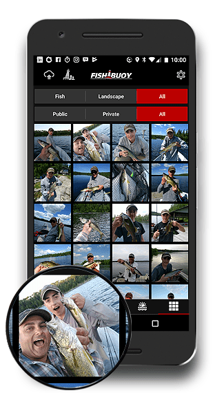
Every photo you take with FISHBUOY Mobile becomes a visual waypoint of your fish catches. Select an individual photo, find out the environmental conditions you encounter when you caught that fish. |
|
Digital Fish Log |
FISHBUOY Mobile is an essential tool that will help you capture and organize your fish catches digitally. Each photo is a "FISH" "BUOY" - a digital log of your fish catch with statistical and environmental data attached. This helps you to learn and plan for your next trip using physical information you already captured. |
|
Fish/Landscape Gallery |
Sometimes, you just want to take a photo of a sunset or other non-fish photos. Switch to landscape view with simple swipe of the switch and take photos while you help rehabilitate a trout stream, participate at a fishing tournament, etc. |
|
Private Groups |
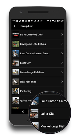
Create private groups to share fishing spots with your closed circle of fishing friends. Create groups to help you organize your fishing history into locations or species. Whatever you decide, it is easy to add or remove people! |
|
GROUP FEATURES |
SHARE IMPORTANT DETAILS WITH YOUR FISHING BUDDIES |
|---|---|
|
Customizable Groups |
Groups offer a convenient way of organizing your catches by fish species, lakes/rivers, lodges/resorts, location, etc. |
|
Control Information |
Allow group members to invite others and/or share photos within the group. |
|
Share Locations |
When you share a fish photo, you share all the associated information including location, water and weather conditions and primary bait color. |
|
Collective View |
A combined view of fish catches will help you learn when and where to fish. |
|
MARINE CONDITIONS YOU SHOULD KNOW ABOUT | |
|---|---|
|
WAVE HEIGHTS |
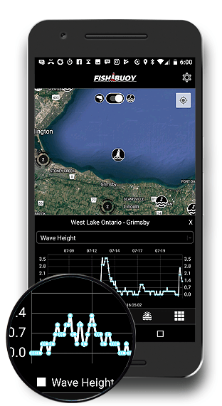
We connect directly to NOAA's vast network of North American marine buoys to help you understand the wave conditions you are heading into. Anglers use this information for boater safety in addition to selecting where on a lake they will fish first. |
|
MARINE WINDS |
Understanding historical and current wind conditions can help anglers determine potential areas holding fish. WInd direction and magnitude influence water currents. These changes move food sources and bait fish to different areas of the lake. |
|
AIR PRESSURE |
Start tracking how changes in barometric pressure affect certain species of fish. Capture pressure with each photo, then refer to historical and real-time values in the field to plan for your next trip. |
|
SURFACE WATER TEMPERATURE |
Open water fishermen know the importance of surface water temperature tracking. FISHBUOY exposes real-time and historical water temperatures so you can locate your target species. |
|
KNOW YOUR WEATHER, PLAN YOUR DAY RIGHT. | |
|---|---|
|
Doppler Radar (Precip) |
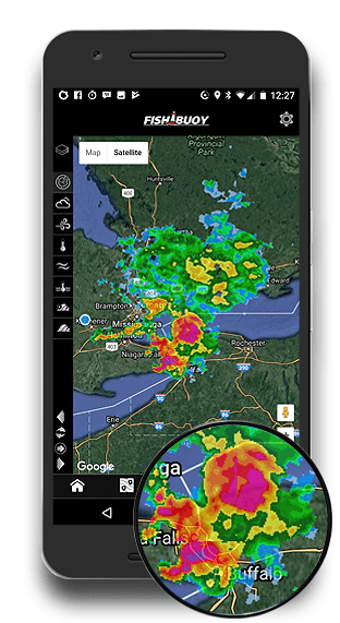
Get up-to-date doppler weather maps showing precipitation events and intensity. |
|
Wind Conditions |
Whether planning a fly fishing trip or hitting the lake, gain a better understanding of wind conditions before you head out. |
|
Cloud Cover |
Direct from Enviroment Canada, determine whether to bring your Maui Jim sunglasses, rain gear or sun screen. Not to mention, don't forget your low-light lures! |
|
Air Temperatures |
Are you heading into icy cold temperatures that will freeze your guides, or sweltering heat that will kill your minnows and live bait in a few hours? Know what you are heading into. |
|
INTERACTIVE MAPS THAT HELP YOU RETRIEVE INFORMATION | |
|---|---|
|
Geographic Location |
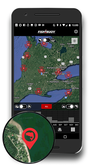
Each time you take a photo with FISHBUOY Mobile, you add to your portfolio of fish catches. With a few simple clicks you can pull up your fish catch locations, date and time, water conditions, weather conditions, species of fish, and much more! |
|
Timing |
How many times have you been out with your fishing friends, anxiously planning your next trip together? Inevitably, you begin to refer to your past fishing trips and 9 times out of 10, you argue about the location, conditions and of course, size and quantity of fish. As a map-centric application, FISHBUOY Mobile helps you to quickly access those historical fish catches and provides measurable information - no more need for guessing. |
|
Trend Building |
Your catches are plotted on a map helping you to conduct indepth analysis of your fishing success - using spatial and temporal techniques. A big advantage with FISHBUOY Mobile is that you can combine public photos posted by others, with your photos, to get a statistically sense of where the best locations are to fish. |
|
Getting Back to Your Spot |
While on the water or hiking across lands, FISHBUOY Mobile offers real-time tracking of your current location relative to your fishing spots. Like a navigation system, FISHBUOY Mobile will help you get to your fishing hole. |
|
MEASURE THE LENGTH AND GIRTH OF YOUR FISH. ESTIMATE THE WEIGHT. | |
|---|---|
|
Overview |
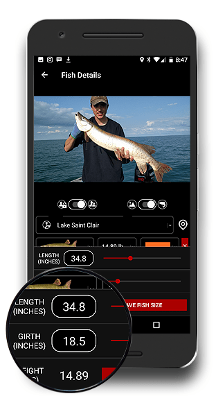
The built-in automatic weight estimator was based on the original OFAH weight calculator. This is an extremely handy feature that allows you to enter the length and girth measurements at the time you take a photo. This provides fishermen a math-based option for estimating fish weight versus guessing. |
|
Outings/Catch-and-Release Events |
Planning a fishing tournament that involves catch-and-release? FISHBUOY Weight Estimator is a great option when running events that require fish to be quickly returned to the water. Musky for example are too sensitive to transport to weigh-in stations. This Weight Estsimator is a means to have all fishing participants use a single and consistent tool to measure fish. |
|
The Guessing Game |
Why not estimate fish weight using proven methods? Though most fishermen estimate fish weight within 1-2 pounds accuracy (wink wink), sometimes a more accurate approach is needed when comparing notes with fishing buddies. Bragging rights? Why not compare using a consistent method? |
|
QUESTIONS? Feel free to drop us a line - click here. One of our representatives will get back to you as soon as possible. |
|---|

